From T. F. Jamieson 3 September 18611
Dear Sir
I returned a few days ago from a trip to Lochaber where I spent a fortnight and now hasten to present you with some of the results of my visit,2 and I may at once state that all I saw tended to impress upon me the conviction that these parallel roads have been formed along the margin of freshwater lakes and finding the marks of ice action so plain over the whole district I cannot help thinking that Agassiz hit upon the true solution of the problem when he pronounced these marks to be the effect of glacier-lakes.3 I attentively examined the entrance to Loch Treig, and found both sides of the gorge to present the clearest evidence of most intense glacial action, and that to heights of many hundred feet above the like-rounded rocks, scores, flutings & perched blocks abound and all these phenomena are most conclusively seen to have been effected by a great volume of ice flowing down the valley now occupied by the Lake, and issuing out by this gorge into Glen Spean. Mr Milne states that the glacial markings here point S.W.4 this is quite true as regards the east side of the gorge, but on the opposite or W. side they point S.E.
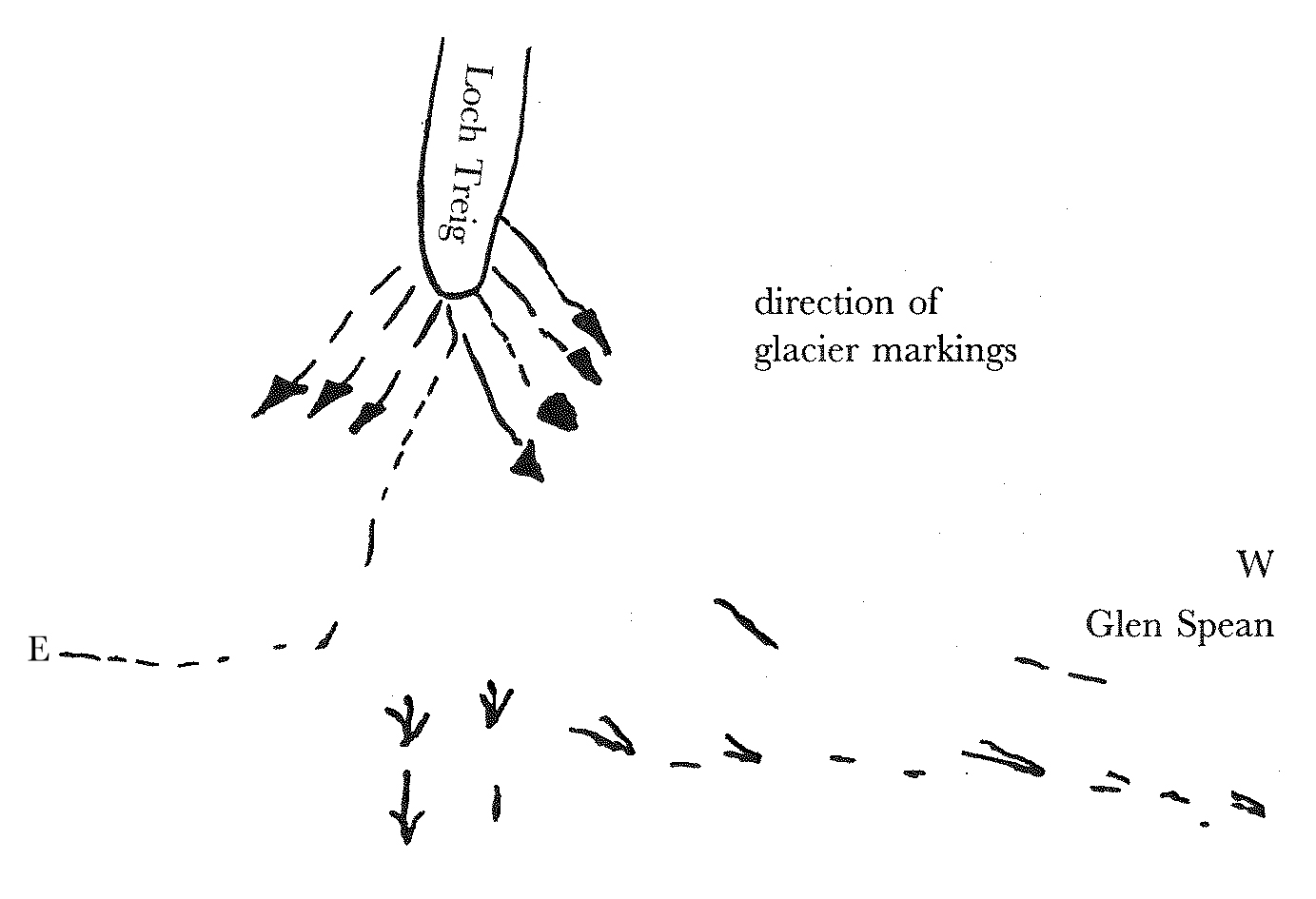
Mr Milne says he could find no transverse scratches on the rocks of Glen Spean. I was however more fortunate and found them on the north side of the Spean opposite the entrance to Loch Treig, as Agassiz had correctly described. The profusion of blocks on this side of Glen Spean over an immense expanse is very striking—in fact the whole ground about the mouth of Loch Treig is a perfect study of glacial action. I could see no line of erosion due to water action on either side of the entrance and have no doubt that the rounding you noticed was simply the glacier action which is there very conspicuous & striking.5 I indeed noticed some scores & furrows on this level of the shelf. I should also mention that the protrusion of glacier from Loch Treig across Glen Spean would, by resting on the north side of that valley, block up the outlet at the head of Glen Glaster so that this Glen Glaster outlet does not (as Mr. Chambers supposed) present any great difficulty on the Glacier theory.6
I went up to the head of Loch Treig and explored a wild glen which runs from the S.W. corner of the Lake to Spean-bridge & called the Larig or Larig Leachach.
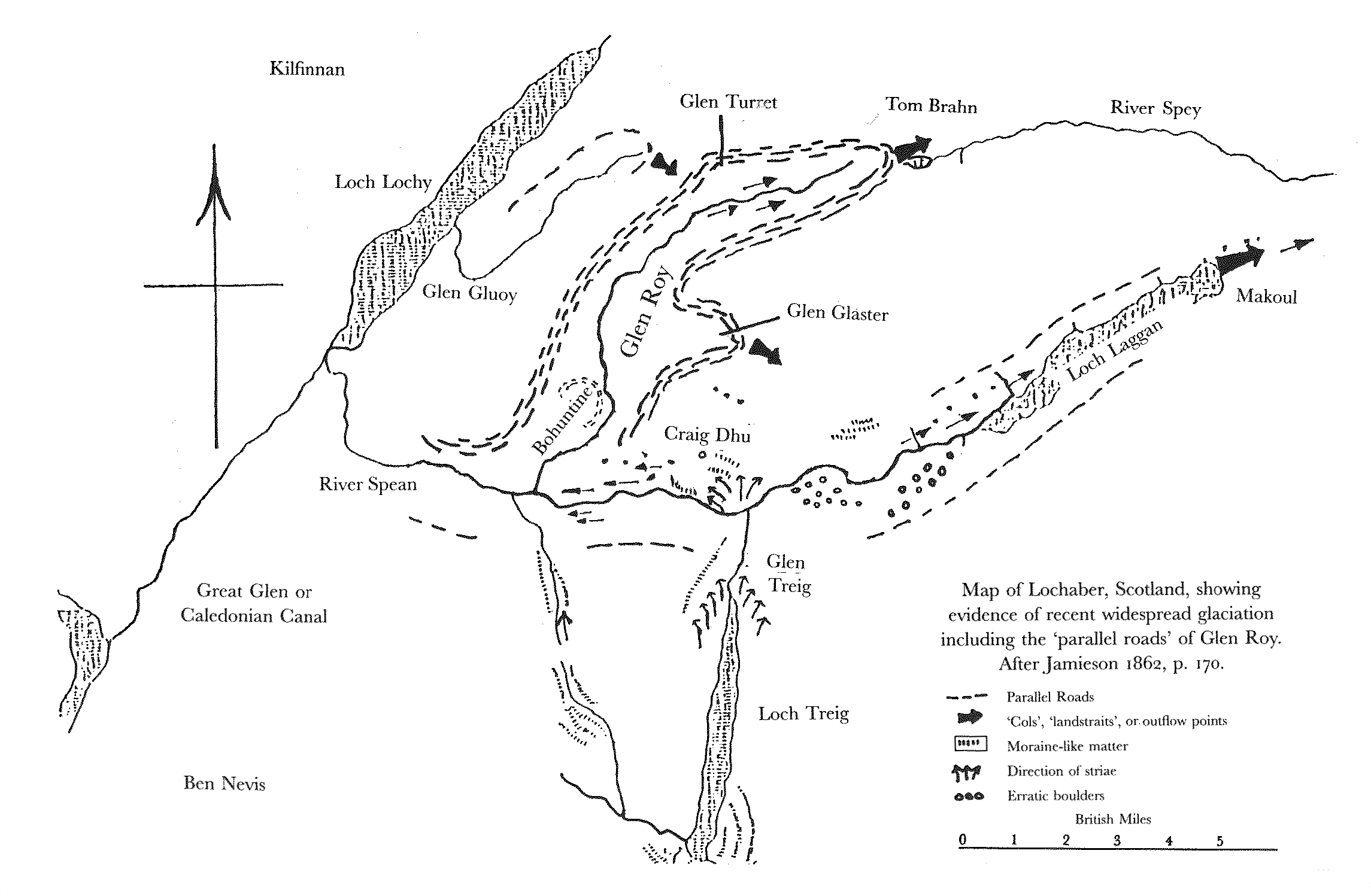
There is no trace of any line round the head of Loch Treig, nor in fact round any part of it, altho’ Sir Lauder Dick says it is visible on the W. side.7 There are some indications of alluvial detritus here & there towards the lower end of the Col.—but a marked absence of such at the upper end & instead I found hillocks of what seems to be Moraine matter abounding in blocks. There is an absence of all deltas at the mouths of the streams that come into the head of the lake at levels above the present upper limit of its waters which leads me to think that the upper end of the lake must have been occupied by the glacier during the time when the waters in Glen Spean stood at the level of the lowermost line of Glen Roy. In traversing the Larig glen I found much evidence of glacier action but not lines like those of Glen Roy.
The only place where I observed any wearing away of solid rock due to the action of the waters that had formed these Glen Roy lines was at the head of Glen Roy or rather what has been called the head of Lower Glen Roy, where there is a sort of pass caused by a set of rocky eminences in the hollow of the glen.
Here also there had been previous glacial action so that it is not easy to determine how much is properly due to the effect of water. This pass is a notable place for wind (as I can testify, having been nearly blown off my feet there) which coming up the long hollow of the glen rushes over this high narrow pass with immense force, and when the water stood at the levels of the two uppermost lines of Glen Roy it would lash against these rocks with considerable force during gales from the S. W.
On the face of the hill marked Tom Brahn in your map8 the shelves are more broadly & rudely marked than any where else that I saw. This broad marking however consists of a protrusion of loose matter, and I could find no noticeable erosion of rock along any of the lines. The middle line crosses a mass of solid rock in situ here which I examined with the view of detecting traces of such erosion but the angles were quite similar to such as are usually to be found on weathered rocks not exposed to the flow of water.
At the West end of Loch Laggan there is clear evidence of the water having formerly stood at a height of probably 40–50 feet above their present level, there being a great bank of alluvial matter to that height which seems to have been the delta of the Gulban river Along the shores of Loch Laggan however there is no clear trace of any line that I could see, most of it indeed is so encumbered with block & rocks that the mark of a line could scarcely be expected. At the E. end there is also evidence of the lake having formerly stood at a higher level than at present and that to such a height as would, I have no doubt, cause its waters to flow eastward by Makoul towards Spey at the pass of Makoul (or Muckul as it has been written by some) or rather a little to the Eastward of it there is clear evidence of a large stream of water having flowed out towards the basin of the Spey, although I should describe it somewhat differently from Mr Milne. There has no wall-sided gorge been cut there is a ravine due to a series of rocky eminences occupying the middle of the valley. Here also there had been previous glacial action, but the subsequent effects of water flowing eastward are quite unmistakeable. The glacial scoring has been washed out & smooth winding curves with a tendency to form potholes are seen, whilst quantities of well rounded pebbles like cocoa nuts or cannon balls lie on the water-worn surfaces, and heaps of shingle in the recesses and sheltered spots to the East of the rock masses. This shingle is intensely water-worn & has been used in some places for making the road. I satisfied myself that this could not have been caused by tidal action but that it was due to a current flowing downward and Eastward—9 In the rocky narrows a little above the height of the summit level where tidal action would also infallibly have left its trace I found stony detritus but presenting none of the water-rolled complexion of that which I have described. As there is no clear line along the E. end (or indeed almost any where else) of L. Laggan I doubt much whether this Makoul outlet has ever been properly connected by levelling with the lower line of Glen Roy, although I think it is highly probable that it does coincide with the level of that line. The outlet at the head of Glen Glaster does coincide with the middle line of Glen Roy & here also there appears to have been an outflow of water. The outfalls at the head of Glen Gluoy & Loch Spey I was unable to visit. In looking up Glen Roy from the Gap, I was much struck by the extreme neatness & precision of the lines which seemed to me very unlike what might be expected from the shore of a lake subject to tidal action. Very different from the appearance of true old coastlines which I had seen on the West coast of Argyleshire last summer, & also from those depicted by M. Bravais.10 But what seemed to me even more important evidence in this respect was the wonderfully fine preservation of the deltas at the mouth of some of the streams near the head of Glen Roy. These deltas have the appearance of being lodged in the waters of a placid lake, even in a stagnant pool, so undisturbed is the outline of some of them. This seems inexplicable to me had the lake been an arm of the sea, subject to the flux & reflux of the tides.
Again the delta at the mouth of the Turret is out of all proportion too large for the size of the stream. I estimated the waters of the Roy as 3 or 4 times greater than those of the Turret at their point of junction whereas the Turret delta is 2 or 3 times bigger than the Roy delta. This I think can be explained only by supposing the Turret delta to be partly due to the outflow from Loch Gluoy. The glacier streams that had blocked up the mouth of Glen Spean have probably been those issuing from Glen Arkarg & the other glens at the mouth of the Caledonian Canal. At Fort Augustus the traces of glacial action are very noticeable.
In Glen Spean to N.E. of Bridge of Roy the scores run E. & W. but further up they sweep beautifully round into the mouth of Glen Treig opposite which they run N. & S. The glacial markings on the syenitic granite on the N. side of Glen Spean opposite the entrance to Loch Treig are amongst the finest specimens of ice-work I have seen, this with the heaps of moraine matter & the perfect wilderness of boulders made me stare with astonishment how any one, after Agassiz had drawn attention to all this, could go on the ground & yet deny that there had been any glacier here!11 I do not suppose there is any place in Britain where the traces of a great ice stream are more complete.
There are however some facts connected with the former glaciation of Lochaber very remarkable but they refer to a period anterior to the formation of the parallel lines, and although very extraordinary they are consistent & harmonise with what I have seen in other parts of Scotland. They indicate however a climate more like that of the poles than any thing else we have at present on the face of the globe, & the state of things which they disclose seems to me one of the most curious & inexplicable in the whole range of the geological record12
I have written the above notes very hastily but shall be happy to answer any queries you may wish to put. I may mention that I had most villainous weather, which prevented me making so long excursions as I otherwise might have done; and it was only by going doggedly to work with a waterproof & umbrella that I could get any thing done at all.
Yours ever | Thos. F. Jamieson
Ellon, Aberdeensh.
3d. Sept. 1861.
Footnotes
Bibliography
Autobiography: The autobiography of Charles Darwin 1809–1882. With original omissions restored. Edited with appendix and notes by Nora Barlow. London: Collins. 1958.
Barrett, Paul H. 1973. Darwin’s gigantic blunder. Journal of Geological Education 21: 19–28.
Bravais, Auguste. 1845. On the lines of ancient level of the sea in Finmark. Quarterly Journal of the Geological Society of London 1: 534–49.
Chambers, Robert. 1848. Ancient sea margins. Edinburgh.
Collected papers: The collected papers of Charles Darwin. Edited by Paul H. Barrett. 2 vols. Chicago and London: University of Chicago Press. 1977.
Correspondence: The correspondence of Charles Darwin. Edited by Frederick Burkhardt et al. 29 vols to date. Cambridge: Cambridge University Press. 1985–.
Lauder, Thomas Dick. 1823. On the parallel roads of Lochaber. [Read 2 March 1818.] Transactions of the Royal Society of Edinburgh 9: 1–64.
Rudwick, Martin John Spencer. 1974. Darwin and Glen Roy: a ‘great failure’ in scientific method? Studies in History and Philosophy of Science 5 (1974–5): 97–185.
Summary
Observations from a fortnight in Lochaber. Found the entrance to Loch Treig to present the clearest evidence of intense glacial action. States, in contradiction of David Milne-Home, that there is glacial scoring in Glen Spean, as Louis Agassiz described, and moraine around the mouth of Loch Treig. There is little sign of water erosion on the rocks crossed by the lines in Glen Roy. Believes the smoothed rocks at the eastern end of Loch Laggan are due to flow from the lake and not tidal action. The lines in Glen Roy are too neat for a lake shore subject to tides. Given the glacial scoring sweeping round from Glen Spean into Glen Treig, and all the boulders, TFJ is astonished that anyone could deny that there had been glaciers there. [See 3247.]
Letter details
- Letter no.
- DCP-LETT-3242A
- From
- Thomas Francis Jamieson
- To
- Charles Robert Darwin
- Source of text
- The University of Edinburgh Centre for Research Collections (Lyell collection Coll-203/A3/7: 75–92)
- Physical description
- CC 18pp CC
Please cite as
Darwin Correspondence Project, “Letter no. 3242A,” accessed on 19 April 2024, https://www.darwinproject.ac.uk/letter/?docId=letters/DCP-LETT-3242A.xml
Also published in The Correspondence of Charles Darwin, vol. 9